

The Incredible View of Mont Blanc from Mount Snowdon | Quick Guide
Mont Blanc visible at 1,127 km !!! – 6 Mar 2022 | Nouvelle Géographie PLANétaireMont
Mont Blanc visible at 1,127 km !!! – 6 Mar 2022 | Nouvelle Géographie PLANétaireMont
Impossiball?
The Welsh iPhone Snapshot That Went Viral and Annoyed Its Photographer
It seemed like an ordinary photo from Snowdon, until distant peaks appeared, sparking claims that Mont Blanc itself had somehow been captured impossibly on camera.
On 25th of July 2021, Andrew Baillie took a photograph with his iPhone at the top of Mount Snowdon entitled ‘View to Y Lliwedd from mount Snowdon’. Little did Andrew realise that his photograph would cause quite a stir as it appears that unbeknown to him, not only had he taken a lovely picture of Snowdonia and its surroundings on a beautiful clear day, he had also captured the mountains of the french alps and Mon Blanc in the distance. But did he?

Far Far Away
In a reply to a comment on Flickr, Braillie writes,

“That was partly what drew me to the view – the snaking path down the side of the mountain, as well as the sharp peak and the views beyond.”
Andrew Baillie
In a now deleted comment, cheeky eagle-eyed Gaspard Beaumont responds,
“and “the views beyond” take us very, very far…. ^^”
This incredible observation inspired many to grab their calculators and do the sums. Eight inches per mile squared, a total distance of 1,125.91 km (699.61 mi) at an elevation of approximately 1,085 metres (3,560 feet) above sea level. It shouldn’t be possible, right? But here we are, it certainly does look like the peaks of the alps and Mont Blanc in the distance, no? What do you think?
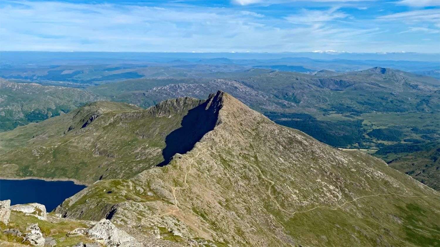
Not Amused
You may expect that one would revel in the joy of having captured an apparently impossible image but unfortunately it would seem that Baillie is not at all amused. Instead, he has opted to make the photograph ‘adult content’ and deride those interested in the extraordinary image. Rather than allow people to scrutinise his photo, Baillie has elected to completely alter the image, removing the offending background in Photoshop to this:
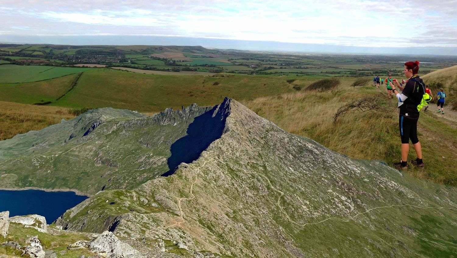
In a recent comment on his Flickr page, Braillie wrote the following,
“HELLO!
If you’ve arrived here from watching a flat-eather’s video or someone’s video debunking a flat-earther’s video, then welcome.
I’ve doctored the shot that you see. It didn’t look like that originally. I amended it so that no-one will want to lift the photo from this site (as a few people have already done) to make inaccurate videos speculating how far one can see around the globe.
The above is pretty much what was there before, but with the debatable bits removed, such as clouds that people have mistaken for mountains in the distance, or a horizon that could be mistaken for, I don’t know, a cheese roll, a Toblerone mountain, or an inflated sense of importance.
No correspondence will be entered into, so don’t try to contact me about what this shot used to look like. I’m not interested.
Many thanks”
Andrew Baillie
The updated image description now reads,
“View to Y Lliwedd
One of those wonderful days where you can see the South Downs from the Top of Mount Snowdon!
Beyond Y lliwedd, you can see the village of Alfriston as well as the ridge to Bo Peep and Firle Beacon.And of course, the Ice Wall just beyond.”
Taken on my iPhone.
Quite witty perhaps if a little puerile. Defacing possible evidence of extraordinary phenomena, totally unnecessary.

It’s clear that Braillie wasn’t happy with people using his image without permission and creating, as he puts it, “inaccurate videos speculating how far one can see around the globe” but it’s worth noting that the image was publicly available before he locked it behind Flickr’s ‘adult content’ door, and UK copyright law has explicit exceptions to copyright that allow for criticism, review and teaching.
One question still remains, can we see Mont Blanc and the French Alps in Andrew’s original photograph? If so, how? We’re not supposed to be able to see that far…
Perhaps, as ABC weatherman, Tom Coomes puts it,
“What you are seeing there is a mirage.”
Tom Coomes – ABC News
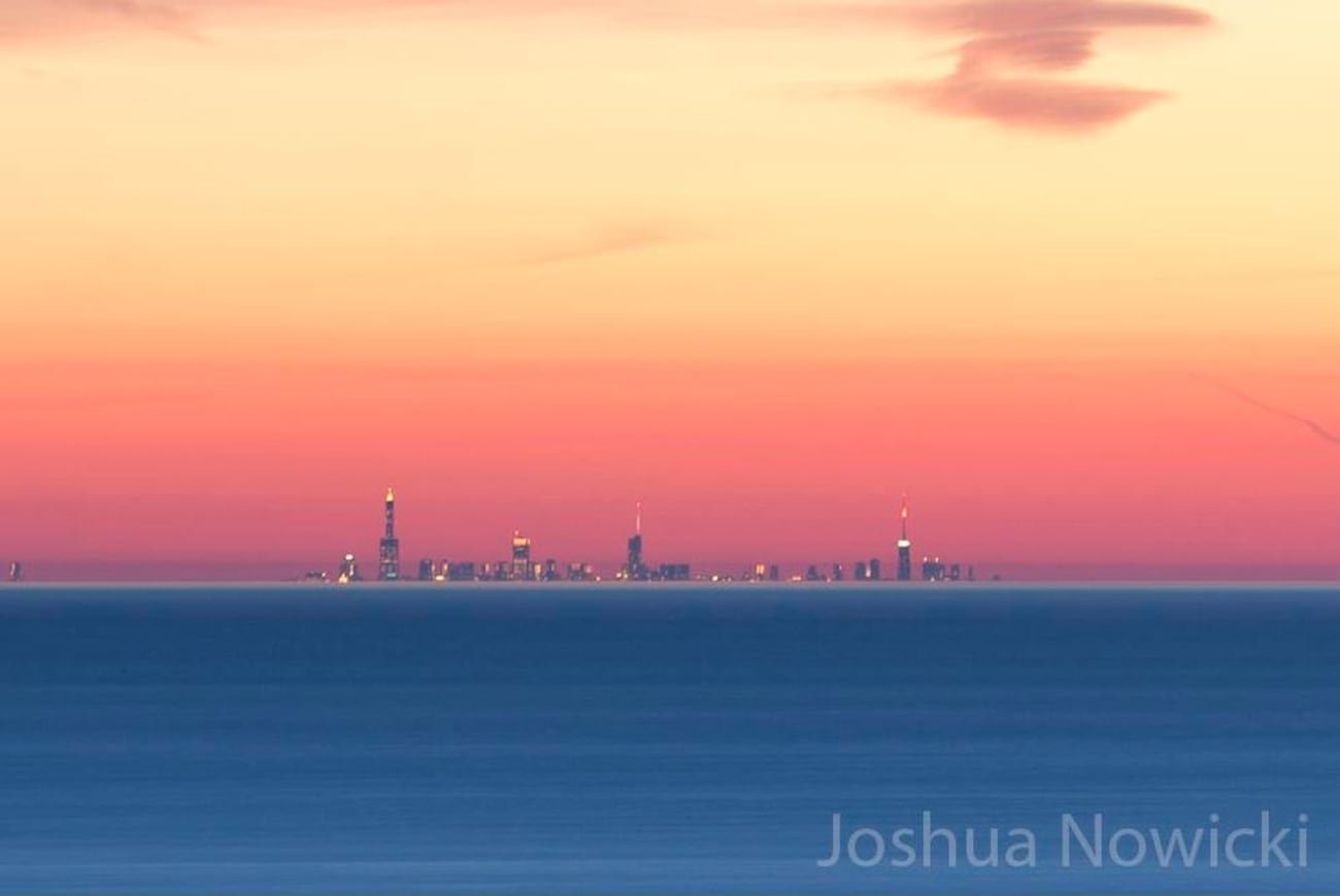
Another well known example of us being able to see too far, is the view of the Chicago Skyline photographed by Joshua Nowick from Warren Dunes State Park on the Michigan shoreline, about 50 to 60 miles away. ABC weatherman, Tom Coomes, actually told his viewers that Nowick’s picture of the Chicago skyline is a mirage, despite the main characteristics of a mirage being shimmering or wavering air, blurry and distorted distant objects, displaced or upside-down images, and a false “water” reflection. Mirages are usually over hot surfaces like deserts, roads, or pavement, where warm air near the ground bends light and creates the illusion of water or distorted objects.
So using the standard curvature calculation formula (eight inches per mile squared), the Earth’s curvature drop below the line of sight grows with the square of the distance in miles.
For a target 60 miles away, the curvature drop can be estimated as follows:
Square the distance: 60 miles × 60 miles = 3,600
Multiply by 8 inches: 3,600 × 8 inches = 28,800 inches
Convert to feet: 28,800 inches ÷ 12 = 2,400 feet
Subtract observer height: 2,400 − 240 = 2,160 feet
This means that, accounting for an observer height of 240 feet (the highest point at Warren Dunes State Park) over a distance of 60 miles, the surface of the Earth supposedly curves downward by about 2,160 feet (approximately 730 meters). So the bottom of the Chicago skyline should be about 2,160 feet below a straight line of sight due to Earth’s curvature, which it is not.
Claims that the skyline photo at that distance is simply a mirage caused by atmospheric refraction ignore this significant curvature effect. The buildings should largely be hidden below the horizon if Earth’s curvature is legit.
Nowicke has photographed the same view on multiple occasions and made a number of time-lapse videos of the Chicago skyline. Does this look like a mirage to you?
Time-lapse: Looking toward Chicago from Michigan – 30 April 2015 | Joshua Nowick
Time-lapse: Looking toward Chicago from Michigan 2 – 30 April 2015 | Joshua Nowick
Time-lapse: Looking toward Chicago from Michigan 2 – 2 May 2015 | Joshua Nowick
Clear View Shock
But we digress, perhaps the real news to report here is not that you can see further than you’re supposed to see but that there’s evidence of a clear view from the top of Mount Snowdon. That’s a bloody miracle!
What does the AI say? According to Perplexity, the distance between Mount Snowdon and Mont Blanc is about 1,127 kilometres (around 700 miles). Using the standard curvature estimation formula (eight inches per mile squared), the Earth’s surface drops very significantly over such a large distance.
Over 700 miles, the curvature drop is approximately 3,920,000 inches, which is about 326,000 feet (around 100 kilometres) below a straight tangent line.
This means that, ignoring elevation and atmospheric effects, any distant object at that range would lie far below the geometric horizon. Even when accounting for the elevations of Mount Snowdon (1,085 m) and Mont Blanc (4,808 m), the line of sight between them should still be blocked by Earth’s curvature.
Atmospheric refraction can slightly bend light and extend the visible range, but not nearly enough to compensate for a drop on the order of 100 kilometres. Therefore, Mont Blanc cannot be directly visible from the summit of Mount Snowdon under normal Earth curvature conditions.
Right. OK.
So, based on Earth’s curvature using the eight inches per mile squared rule, Mont Blanc would be roughly 326,000 feet (about 100 kilometres) below the line of sight from Mount Snowdon.
Let’s leave it at that.
The_Void
‘View to Y Lliwedd‘ Photograph Details
Photo: Andrew Baillie – 25 July 2021
“View to Y Lliwedd_From Mount Snowdon“
Apple iPhone 11
f/1.8 – 1/3205s
32 ISO
4.2mm = 30,24mm (equivalent 24×36)
Photo taken on July 25, 2021, at 5:25 p.m.
Sources and links
Advanced Earth Curvature Calculator
Mirage of Chicago skyline seen from Michigan shoreline
What mountain summit has the world’s longest view?
Perplexity: Can you see Mont Blanc from the top of Mount Snowdon?
Looking toward Chicago, Illinois from Grand Mere State Park in Stevensville, Michigan on 4/28/2015 at 9:26pm. – Joshua Nowicki
Source: Impossible View of Mont Blanc from Mount Snowdon
Source: Andrew Baillie – View to Y Lliwedd
Source: Mont Blanc visible at 1 127 km !!! – YouTube
Source: Mont Blanc visible at 1 127 km !!! – Odysee






Leave a Comment
Want to join the discussion?Feel free to contribute!